
Auravant, crop monitoring and mapping tool, is integrated into Operations Center de John Deere, the free and universal app that allows you to make better decisions to obtain the highest productivity and profitability. Both companies will work together to connect machines, persons, technology and intelligence, to produce more efficiently and sustainably.
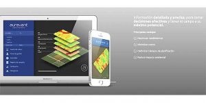
Platform users will be able to transfer the information generated by the machinery fully automatically, being able to generate new maps and analyzes to enhance the development of the agricultural sector. Auravant is a tool that helps professionals in making decisions during the productive stage of the crop, enabling the implementation of precision agriculture in an easy way, fast and economical.
El director in Marketing Global en Auravant, Fernando Calo, celebrate integration “because it makes it easier for Auravant users to use the information available on their John Deere machines, helping to make better agronomic decisions that result in maximizing the productivity of their fields and minimizing environmental impact”.
More of 20.000 professionals are monitoring with Auravant their crops in 7 million hectares in more than 70 countries around the world. John Deere has more than 650.000 hectares and 6.000 machines connected to the Operations Center in Spain. “We continuously work to create collaborative environments with other companies to provide farmers with the necessary tools to obtain maximum profitability from their exploitation and optimize their production in a sustainable way.”, highlights Jaime Muguiro, commercial director of John Deere Ibérica and responsible for Precision Agriculture.
“Thanks to the integration of Auravant and the John Deere Operations Center, now it is possible to collect and analyze all available data such as crop yields, soil maps or satellite images and make an agronomic decision quickly and easily. Zoning the plots, produce a data-based prescription map and send it telematically to the tractor for automatic application, it's a matter of seconds ", the manager concludes.
https://www.interempresas.net/Agricola/Articulos/366958-John-Deere-integra-en-el-Operations-Center-el-monitoreo-y-mapeo-de-cultivos-de-Auravant.html